Recently, a paper on the Yellow River flood hazard by Prof. Yu Shiyong team from the School of Geography, Geomatics and Planning was published on Science Advances, an internationally renowned comprehensive academic journal, with “Human disturbances as the dominant cause of unprecedentedly high frequency of Yellow River flood hazard over the last millennium” as the core idea. The research was funded by the National Natural Science Foundation of China (NSFC) and carried out with the participation of Associate Professor Zhou Liang and Professor Shen Zhixiong from the School of Geography, Geomatics and Planning. Jiangsu Normal University was the only first author institution and the corresponding author institution.
The Yellow River, along with the Yangtze River, is known as the mother river of the Chinese nation. And they give birth to the Yellow River civilization, one of the world’s four ancient civilizations. Through the Longshan culture, which succeeds the Yangshao culture of the Neolithic Age, it develops into the culture of bronze represented by the Erlitou culture, laying the foundation for early China. In fact, the Yellow River is an untamed river, full of complexity and hazards. It is said that “when the Yellow River is calm, the world is at peace.” Through the exploration of past sages and ordinary people, attempts have been made to manage the flood hazards. However, they were not familiar with the river basin’s ecosystem and the management was mainly concentrated on levees and the downstream.After that, a vicious cycle (Fig. 1) of sedimentary, levee overtops and breaches appeared and it has been the history of the relationship between people and the land for the past millennium. In modern times, Li Yizhi first proposed the idea of comprehensive management for the upper, middle and lower reaches, but it was not implemented in the war years. Since 1949, soil and water conservation on the Loess Plateau and Xiaolangdi Hydro Project have been subjected to devastating Yellow River floods. But the prevention and control of Yellow River flood hazards have always been a major scientific problem that hinders the high-quality development of the Yellow River Basin.
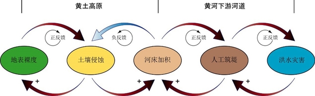
Fig. 1. Cascade effect of soil erosion, riverbed siltation, levee construction and flood hazard in the middle and lower reaches of the Yellow River
Prof. Yu Shiyong, a member of Chinese Academy of Sciences, the “Taishan Scholar” and the “Elsevier China Highly Cited Scholar”, has been devoted to the study of ancient flood disasters and environmental evolution in the Yellow River and Huaihe River region. The study led by Prof. Yu, based on years of research accumulation, calculated the frequency of flood hazards in the middle and lower reaches of the Yellow River over the past 10,000 years by integrating geological, historical documents and hydrological observations through Bayesian simulation (Figure 2). The result reveals that flood events in the Yellow River basin became almost an order of magnitude more frequent during the last millennium than before and 81% of the increased flood frequency can be ascribed to anthropogenic disturbances. The simulation analysis confirms that positive human intervention (soil and water conservation) can significantly reduce the flood frequency. Currently, levee construction remains the preferred flood control measure in most parts of the world. Flood control experience from the Yellow River over the past 2,000 years proves that engineering measures can only produce short-term benefits and must be combined with integrated watershed management to achieve long-term flood control. The research results provide Chinese wisdom for flood control and disaster reduction in other human-disturbed large rivers in the world. The results have been reported by domestic media such as the South China Morning Post and Science Net.com.
Link: https://www.science.org/doi/10.1126/sciadv.adf8576
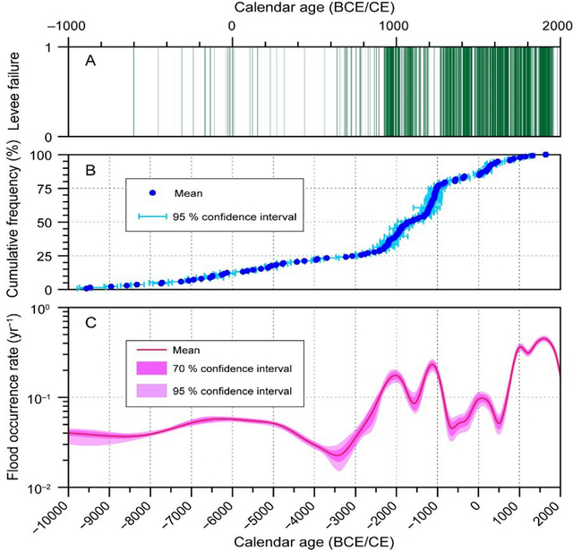
Fig. 2. Reconstruction of Yellow River flood frequency during the last 12,000 years.
(A) Documentary record of levee beaches and overtops. (B) Modeled calendar ages of paleo-flood slack water deposits. (C) Gaussian kernel density estimation of flood occurrence rate.